Travel
Winter storms with rain, snow could snarl holiday trips for millions as record-setting Christmas travel begins

A relatively calm Christmas holiday is in the cards across the U.S., but there are a few spots that could see a few travel troubles.
NEW YORK – Millions of Americans are gearing up for Christmas travel, but inclement weather could dampen their festive plans.
While no major storms are forecast to disrupt holiday travel entirely, rounds of rain and winter weather are expected to slow things down, especially in the eastern U.S. With nearly 120 million people expected to travel this year – a record number of people for the Christmas period, according to AAA – it’s crucial to plan ahead and be flexible.
(FOX Weather)
Lessons were already learned Friday when snow swept across the lower Great Lakes into the Northeast triggering ground stops in Chicago, Boston and New York City for hours. Nationwide, there were over 13,000 delayed flights and hundreds more canceled Friday.
CHRISTMAS TRAVEL TRACKER: LIVE MAPS, AIRPORT STATUS, FLIGHT DELAYS, FORECAST AND MORE

(FOX Weather)
Where are the trouble spots heading into the weekend and Christmas Day? Look for inclement weather across the West and the Southern Plains, while some of the coldest air of the season briefly sweeps across the Northeast.
Places seeing a nicer forecast for the big day are most of the central and eastern U.S. While some light rain looks possible for areas such as Atlanta and Chicago on Christmas Day, any last-minute travel should not be majorly impacted. The quieter weather should allow for a smoother travel day on Wednesday.
MOST WEATHER-DELAYED AIRPORTS DURING HOLIDAYS
I-95 corridor sees accumulating snow Friday; may again on Tuesday
A snowy Christmas Eve event is loading up for the Great Lakes that could bring some snow again to the Northeast.
Several inches of snow fell Friday evening across parts of the Northeast, with snowflakes even reaching the Interstate 95 corridor from Philadelphia through New York and into Boston for a period of slippery travel.
About 3-6 inches of snow fell across eastern Massachusetts, Rhode Island and eastern Connecticut by Saturday morning. Boston’s famed Fenway Park reported a solid 6 inches of snow on the hallowed ground of the Boston Red Sox, while the city’s Logan Airport received 5.2 inches. It was the largest snow accumulation in the city since the Blizzard of January 2022.
Lighter snow spread south along the Interstate 95 corridor into New York City and Philadelphia into Saturday morning. Sidewalks were covered in snow in New York City, where around 2 inches of snow fell, marking the first measurable snowfall of the season.
Ground stops were common across airports in Boston and New York City Friday, but clearer skies and drier weather should improve travel conditions over the weekend.
However, another weak disturbance looks to move through the region Christmas Eve, and with cold air lingering in place, it could bring a renewed mixture of rain and snow to the Northeast.
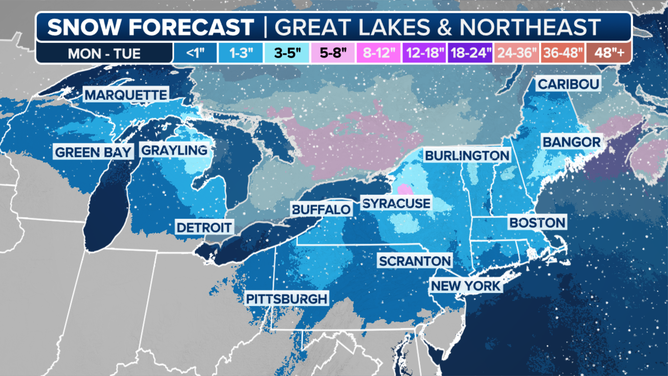
Christmas Eve Snowfall Forecast
“By Christmas Eve, there’s going to be just an uplift in the atmosphere, a little bit of moisture working its way in with that high (pressure center) shifting off to the east, we get that moisture surge coming off the Atlantic. So I think we could see the potential here of maybe getting a little bit of a wintry mix, some snowflakes flying for Christmas Eve,” said FOX Weather Meteorologist Jane Minar. “Maybe a little bit of measurable snow. I think most of that is going to come for the elevations. It’s light snow at that. We’re not expecting anything blockbuster going into Christmas. It’s going to likely be rain closer to the coast.”
The I-95 corridor will be right on the edge of the rain-snow line.
“We will see how all of this plays in to the forecast, especially on where that high (pressure) sets up, where the weak storm system – that weak low as it drifts out of the Great Lakes. But there’s still the possibility – maybe not measurable snow like we had (Friday) night, but maybe a couple snowflakes that might add to the magic.”
Relentless rounds of rain, mountain snow to smack West Coast
The FOX Forecast Center is tracking a series of storms moving into the West and Northwest for the start of the weekend. While generally, these will be weak to moderate events through Christmas Day, the prolonged period of windy and unsettled conditions will remain into the holiday week.
The flooding risk looks to remain low into the start of the weekend, but that changes by Monday.
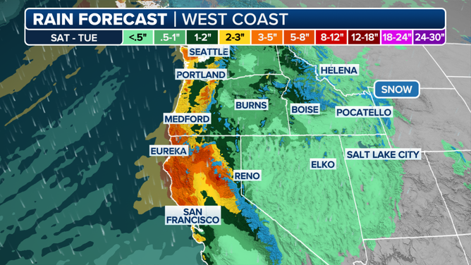
A look at the rain forecast along the West Coast through Tuesday.
(FOX Weather)
For portions of the West Coast from San Francisco to Seattle, moderate to even heavy rain could result in a low-end risk for flash flooding, starting next week. Through Tuesday, portions of Northern California and coastal Oregon could see upwards of 6 inches of rain. Travelers flying through Seattle’s Sea-Tac Airport and the San Francisco Bay Area airports could face delays.
Snow levels remain generally high for this event, so most of the significant snow will be confined to portions of the Cascade Mountains, northern Sierra Mountains and northern Rockies. Feet of mountain snow are likely.
Another heavier round of rain and mountain snow arrives Christmas Day, which will most likely cause travel problems for people heading to and from any holiday gatherings.
Coldest air in nearly 2 years coming to Northeast
While the snow is ending in the Northeast on Saturday morning, an arctic plunge that follows may be most noticeable if you are headed out for any last-minute holiday shopping into the weekend.
Temperatures begin to fall on Saturday but will be majorly felt Sunday morning through Monday with some of the coldest air the Northeast has seen in nearly two years.
DOWNLOAD THE FREE FOX WEATHER APP
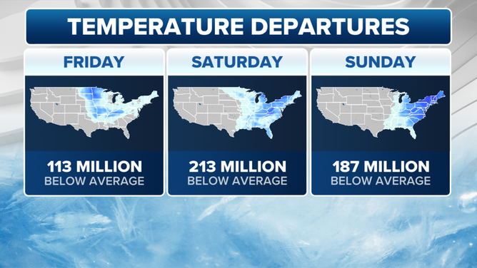
A look at temperature departures in the eastern U.S. through Sunday.
(FOX Weather)
Northerly winds began to usher in the cold Friday night, with over 200 million Americans shivering in below-average temperatures for the start of the weekend.
Highs on Saturday are expected to reach into the 20s and 30s. However, by Sunday morning, low temperatures will drop into the teens and even single digits for interior portions of the Northeast.
When winds gusting up to 30 mph are factored in, it will feel more like the single digits or even subzero in areas such as Boston and Syracuse, New York.
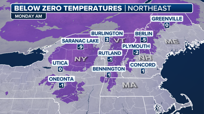
A look at below-zero temperatures in the Northeast on Monday morning.
(FOX Weather)
This cold continues into Monday, the start of the holiday week, too, with many waking up in the single digits. Monday morning could easily go down as the coldest start since February 2023.
Luckily, the chill is short-lived and the warmth engulfing most of the country moves into the Northeast by Thursday.
Thunderstorms expected across South
A slug of moisture from the Gulf of Mexico is expected to fuel heavy rains and thunderstorms across the Southern Plains during Christmas week.
A developing storm system is expected to start tapping into moisture from the Gulf of Mexico on Monday, which could produce a few scattered showers and thunderstorms from Texas into southern Missouri.
Chances of rain will continue through at least Christmas Eve and by the time the precipitation amounts could total 2-3 inches in the Texarkana region.
A few of the thunderstorms could be strong to severe with gusty winds, cloud-to-ground lightning and heavy rainfall being the greatest threats.
Rainfall rates of over an inch an hour could lead to isolated pockets of flash flooding, but most of the rain will be welcome news as the region has been stuck in a drought for months.

(FOX Weather)
Hawaii: Dangerous beach conditions amid 50-foot waves Sunday
If your travel plans are taking you to the warm, sunny beaches of Hawaii, be aware that while the weather looks tranquil for Christmas week, the beach conditions are not.
Dangerous surf conditions with waves reaching dozens of feet high are forecast across Hawaii’s northern beaches as a parade of storm-force to even hurricane-force windstorms is rolling across the Pacific Ocean over the next several days. And while their storm tracks are safely around 1,300 miles north of Hawaii and sparing the islands any direct storm impacts, their deep low pressure centers and ferocious winds are generating massive waves that fan out across the ocean basin.
50-FOOT WAVES FORECAST TO SLAM HAWAII’S NORTHERN BEACHES AMID PARADE OF PACIFIC STORMS
The National Weather Service said satellite data is estimating seas as high as 65 feet near the storm centers, with a nearby buoy measuring 60-foot waves.
Forecast models indicate this fetch of waves is spreading south and will reach the north-facing shores of Niihau, Kauai, Oahu, Molokai and Maui over the weekend. Seas are expected to swell to 30-40 feet on Saturday, growing to 40-50 feet on Sunday. A High Surf Warning is in effect until Monday morning.
End-of-year warmup on the way
From frigid cold to oddly mild, the FOX Forecast Center is monitoring an end-of-year warmup that will impact hundreds of millions as we wrap up 2024.
Forecast models suggest that a fairly strong and intense Pacific jet stream could develop around Christmas out over the middle of the Pacific Ocean. This can have many implications for the weather in the U.S.
Typically, this results in not only a warmer-than-average airmass for the Lower 48, but it can also result in a more active storm track.
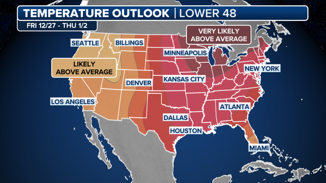
A look at the post-Christmas temperature outlook for the U.S..
(FOX Weather)
The Climate Prediction Center’s extended temperature and precipitation outlook highlights this well, showing all the Lower 48 above average for the week after Christmas, and almost everyone – except southern portions of the Southwest – above average for precipitation.
High temperatures are expected to soar 10-20 degrees above average, with potentially over 200 million feeling the warmth in early 2025.


